WomanGoingPlaces has chosen some of the places we saw as first-time visitors to Japan that became our Top Places in Japan.
Tokyo the capital, of course has many attractions and must be visited, but we would like to present some places outside Tokyo, some lesser known, that made a special impression.
These are to be found on 4 different islands of Japan – Honshu, Miyajima, Hokkaido and Shikoku. The choices are arranged according to islands and not in order of favourites.
We would also like to recommend the following local guides whom we found to be excellent – knowledgable, pleasant and reliable:
Ms. Atsuko Inuzuka Areas guided include Tokyo area, Yokohama, Hakone, Nikko, Kyoto, Kanazawa, Himeji, and Kobe.
Ms.Chiwako Mukai Areas guided principally Hokkaido, but also from Tokyo to Kyoto including Takayama, Kanazawa, Hiroshima and Miyajima.
Mr Masaaki Hirayama Area guided – Hiroshima
HONSHU
KYOTO
Don’t rush through Kyoto. You need to spend time in this city that has more World Heritage Sites than Rome. Plan time to enjoy the extraordinary beauty of the temples and shrines. Allow time to wander through its distinctive districts, extensive gardens and wide boulevards. Eat Shabu Shabu sitting on tatami mats and other traditional food in its excellent restaurants.
Kyoto’s historical importance as Japan’s capital and the Emperor’s residence from 794 to 1868 spared it from air raids in WW2 and the mass, unattractive post-war development of many Japanese cities.
Kinkaku-ji Temple (The Golden Pavilion)

Golden Pavilion Kyoto
The glittering gold Kinkaku-ji Temple and its reflection in the pond is stunning and yet serene. The two top floors of the temple are covered in gold leaf. Built initially by a shogun as his personal villa, it became a temple in 1408. The original building has been burnt down several times, most recently by a fanatic monk in 1950, but each time, like a gold-plated phoenix, it has arisen splendid from the ashes.
You cannot go inside, but must admire it from the outside only. On rare occasions, heads of state and royalty are permitted to enter and see the beautiful interior. Perhaps the luckiest are the cleaning ladies who get regular access to every part.
Fushimi Inari Shrine
This is the head Shinto shrine of 30,000 shrines in Japan dedicated to Inari, the Shinto god of rice. Since 711 A.D., people wishing to give thanks have each donated a torii gate and now there are over 10,000 of these dazzlingly beautiful gates. You walk inside vermillion avenues formed by these torii, each with different inscriptions in bold black.
It is the most popular site in Kyoto and extremely crowded, so try to get there as early as possible in the morning.
HIMEJI CASTLE, HIMEJI

HIMEJI CASTLE
UNESCO describes Himeji Castle as “ a masterpiece of construction in wood”. Sitting on top of a hill, it is a luminous white, particularly brilliant after its recent restoration, and appears to float on its fortified foundations. It is considered Japan’s most spectacular castle for its imposing size and beauty and its well-preserved complex of 83 buildings. Begun as a fort in the 14th Century, it was remodelled and expanded in the 16th Century. Despite war, earthquakes and fires, it remained intact, making it one of Japan’s twelve remaining ‘original castles’. It is also one of only four castles in Japan that has been designated as a National Treasure and has also been designated as a UNESCO World Heritage Site.
A superb example of typical Japanese castle architecture, the intricate detail of every feature from the immense trees used as pillars to the feudal family crests in the tiling reflects extraordinary craftsmanship and ingenuity. Himeji Castle combines the strength of an immense fortification with the lightness and beauty of traditional Japanese aesthetic.
KOYASAN, Mount Koya
If you would like to stay in a Buddhist monastery and practise meditation, Koyasan, is a beautiful, if remote place to do it – in thickly forested mountains at an elevation of 900 metres. Considered one of Japan’s most sacred sites, it is the world headquarters of the Shingon School of Esoteric Buddhism and was established in the year 816 by Kobo Daishi. He is considered by many to be the most influential religious person in Japanese history and his mausoleum is there in the sprawling Okunoin cemetery.
Koyasan has 117 temples. The Garan Temple complex in particular has very intricately designed, remarkable temples set in extensive gardens. Koyasan is a UNESCO World Heritage Site. For over a thousand years, pilgrims have made the lengthy journey here. You see them still, wearing white cotton jackets, with conical hats on their heads and wooden staffs in their hands. Like every place in Japan that attracts many visitors, there are shops, restaurants and even cafes to cater to guests. More than 50 of the temples and monasteries also offer lodgings, known as shukubo. See our post about Ryokans in Japan for more about shukubo and how to contact them.
HIROSHIMA
The destructive power of the the first atomic bomb that was dropped over Hiroshima on August 6, 1945 obliterated nearly everything within a two kilometer radius. It was decided not to rebuild the blast area, but to turn it into Hiroshima’s Peace Memorial Park. You may be disinclined to visit a place of such harrowing memories but it is very worthwhile to do so. Hiroshima itself has been rebuilt into a thriving attractive city. The memorials to the terrible events of the war are thoughtfully and sparely presented. Through personal belongings, clothes and stories they evoke the impact and consequences of that fatal day.
The Museum on the site focuses on August 6 – the day the bomb was dropped and its outcome in human suffering. Scorched items of clothing, personal effects and buildings that survived the 3000 degree heat generated by the bomb make for a devastating display.
The Children’s Peace Monument was built to commemorate the death of children in the atomic blast, and in particular the death of 12 year-old Sadako Sasaki. She was 2 years-old when exposed to the radiation of the blast, but grew up healthy until 10 years later when she was diagnosed with leukaemia. There is a Japanese legend that if you fold 1000 paper cranes, your wish will come true. So Sadako began to fold paper cranes hoping to become well. Some of these cranes can be seen in the Museum. The Children’s Peace Monument has a bell you can ring in commemoration and it is ornamented with colourful paper cranes sent from all over the world.
The A-Bomb Dome, also known as the Hiroshima Peace Memorial, is what remains of the former Prefectural Industrial Promotion Hall. When the bomb exploded, it was one of the few buildings to remain standing, and remains so today designated a UNESCO World Heritage Site.
Between the Museum and the A-Bomb Dome is the Cenotaph. This is an arched tomb for those who died as a result of the bomb, either because of the initial blast or exposure to radiation. Below the arch is a stone chest holding a register of these names, of which there are over 220,000. The grandfather of our guide when we visited Hiroshima, was one of them.
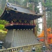
NIKKO
The lavish beauty of the buildings, temples, shrines, gates and bridges in Nikko is extraordinary. This area enshrines the power and wealth of the first Shogun of the Edo Shogunate – Tokugawa Ieyasu. As such, it is a UNESCO World Heritage centre. Pathways through giant trees lead to very long and steep flights of steps into most buildings. There is a feeling of having to ascend into the presence of the all-powerful Shogun. Nikko is 2 hours from Tokyo by train, so a day-trip is possible but would greatly limit what you could see. The area is also a mountain resort.
MIYAJIMA ISLAND
Miyajima Island is considered one of the top three scenic sights in Japan. This island sits in the western part of the Inland Sea of Japan, in the northwest of Hiroshima Bay. It is popularly known as Miyajima, which in Japanese means Shrine Island. There are shrines, temples and historical monuments such as the famous vermillion torii gate that appears to float in the water. Most visitors make a day trip by ferry from Hiroshima. Don’t. It’s worth a longer visit because even if your interest in visiting shrines has waned, it is one of the prettiest and most peaceful places in Japan. Miyajima has retained its traditional character and avoided the high-rise development of most Japanese cities.
Walking through its charming streets you are often accompanied by wild deer, who either ignore you or try to nibble any paper you have in your pockets. There is a challenging but beautiful walk through primeval forest up (and/or down) Mt. Misen. Spectacular panoramic views over the sea await you. You can take the cable car up as well. The specialties of Miyajima are the oysters and the freshly baked, custard-filled sponge cookies. Excellent accommodation is available at all levels of comfort. See our Ryokans in Japan post for more about the Miyarikyu Ryokan.
HOKKAIDO
NOBORIBESTSU
Noboribetsu is famous for its hot springs and volcanoes. A small town in the south of Hokkaido, it is easily reached by train from Sapporo. Set in volcanic mountains, it attracts those who seek the healing and relaxing waters of some of the best onsen in Japan. Noboribetsu Onsen is one of the most popular and famous hot spring resorts. See our Hokkaido post for more about Noboribetsu.
The stark yellow, pink and green-clad landscape is beautiful. Taking a walk along the many pathways through the Shikotsu-Tōya National Park, including the one to Jigoku-Dani (Hell Valley) a huge geothermal crater, is exhilarating. There are cauldrons of bubbling, sulphurous liquid. Geysers periodically erupt in a shower of boiling water.
HAKODATE

Goryokaku Fort Hakodate
Its chief attraction is the five-pointed star shaped Goryokaku Fort modelled on 16th Century European citadel towns and completed in 1864. Its thick stone walls are surrounded by a moat and the 1,600 cherry trees planted in its grounds make it an extraordinary sight in spring. It’s an impressive sight in any season and can be best appreciated from the observatory in the Goryokaku Tower nearby.
The new Goryokaku Tower was built in 2006 as an observatory in order to give visitors excellent perspectives onto the Fort from a height of almost 100 metres.
Hakodate is famed for excellent seafood. This bounty can be seen in over 300 stalls in the morning market (Asaichi).
See our Hokkaido post for more about Hakodate.
SAPPORO

Sapporo Beer Museum
Sapporo, Hokkaido’s capital, is probably best known around the world as the original home of its eponymous brand of beer. It is a thriving pleasant city of almost 2 million people set on a grid pattern that is easy to navigate. Below the city centre, there is a network of underground shopping malls, plazas and public transport that make it possible to live and go about business in the city without suffering the extremely cold winter.
Winter is still an important season in Sapporo because of the annual Sapporo Snow Festival held in February and its astonishing mammoth ice sculptures. Skiing is also an attraction because of the availability of ski jumps in the city and its proximity to the Niseko ski resort. For more about Sapporo see our Hokkaido post.
SHIKOKU
RITSURIN GARDEN, TAKAMATSU
The city of Takamatsu is located on the northern shore of Shikoku, the smallest, least populated and least visited of the four major islands of Japan. Ritsurin Garden is thought by many to be one of best gardens in Japan. It was designed by generations of the local feudal lord and took over 100 years to be completed in 1745. The more than 1,400 twisted and contorted pines set this garden apart from other gardens. Every single day, gardeners hand-prune each of the pines in turn until they complete the 1,400 trees and then start again, removing withered needles and shaping the growth according to a well-defined aesthetic.
The teahouse in the gardens is exquisite with magnificent views over the lake and mountain. Dating back over three centuries, Ritsurin Garden earned the highest rating of 3 stars from the Michelin Green Guide Japan.
MATSUYAMA
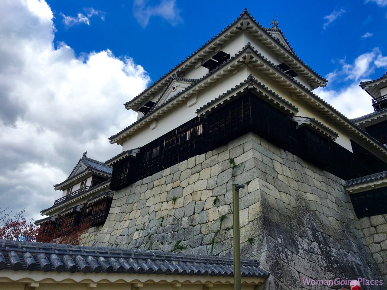
Matsuyama Castle
Matsuyama Castle on the island of Shikoku is another of Japan’s twelve ‘original castles’ which have survived the post-feudal era since 1868 intact. It is located on Mt. Katsu, a steep hill in the city centre providing visitors to the castle with a bird’s eye view of Matsuyama and the Seto Inland Sea. The castle was constructed between 1602 and 1628. The current three storied castle tower was re-constructed in 1820 after the original one was destroyed by lightening.
Related posts:
Onsen in Japan
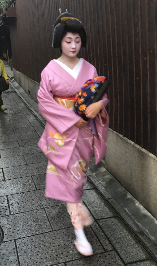
Geisha in Kyoto, Japan
Autumn in Japan
Notes on Japan
Ryokans in Japan
Hokkaido – the Northern Island of Japan
Japan’s Brilliant Bullet Train
The Pleasures of a Japanese Toilet


 But swimming with the sharks and stingrays was much scarier. I was told that the reef sharks are not interested in humans, but when several of them sped towards me, I froze in the water, until they swam by. The stingrays are much harder to spot, as they lie buried in the pure white sand on the bottom, then suddenly rise up, shake off their sand covering and quickly propel themselves away.


 - womangoingplaces.com.au")


